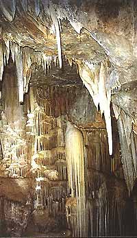
[Sykia Cave at Olympoi, Chios]
|
Geological map of Ierapetra region, scale 1: 25.000 (1966-69) (M.D. Dermitzakis).
Geological map of Armeni-Chandra region, scale 1: 25.000(1973) (M.D. Dermitzakis & N. Simeonides).
Geological block-diagram of the northern part of Agistri & Metopi islands (1973) (M.D. Dermitzakis & N. Simeonides).
Schematic map of recent distribution of Neogene sedimentation areas of the Mediterranean sensu lato (1976) (M.Dermitzakis, in collaboration ).
Geological map of the island of Zakynthos, scale 1: 50.000 (1978) (M. D. Dermitzakis).
Geological map of Southeastern Zakynthos island, scale 1: 50.000 (1979) (M. D. Dermitzakis, D. Papanikolaou, Z. Karotsieris).
Unconsolidated bottom surface sediments of the Mediterranean and Black Seas (1984) (collaboration of international team of UNESCO: A. Brambati (Italy), S.Varnavas and M. Dermitzakis (Greece), A. Monaco (France), O. Neer (Israel)).
Neogene of the Mediterranean Tethys and Paratethys. Sedimentation areas, scale 1: 1.000.000 (1985) (Editors: F. Steininger, F. Rogl, L. Nevesskaja), (M.D. Dermitzakis for Greece, et al. for other countries. Sediment distribution maps of Aquitanian-Late Egerian-Late Caucasian, of Middle Burdigalian-Late Eggenburgian-Late Sakaraulian, of Late Burdigalian-Karpatian-Kozachurian, of Langhian-Early Badenian-Tarchanian, of Early Serravallian-Middle Badenian-Karaganian, of Middle Serravallian-Late Badenian-Konkian, of Late Serravallian-Early Pannonian-Late Bessarabian, and of
Piacenzian-Romanian-Akchagylian.
Geological map and Hydrogeological map of Sykia Olympon Cave of Chios island, scale 1:5.000 (1993) (M.D.Dermitzakis, in coll. with Z. Karotsieris, G. Stergiopoulos).
Geological map and Hydrogeological map of Thrypti-Ierapetra region, scale 1:5.000 (1994) (M.D.Dermitzakis, in coll. with Z. Karotsieris, S. Lozios).
Geological map of Episkopi-Vassiliki region, scale 1:5.000 (1995). (M.D. Dermitzakis, in coll. with Z. Karotsieris, S. Lozios).
Map of lithological phacies along the landing corridor of Vassiliki airport, scale 1:5.000 (1995) (M.D. Dermitzakis).
Map of active faults of Crete scale 1:500.000. Editions of Organization of Seismic Protection (O.A.S.P.) (1996) (M.D.Dermitzakis in coll. with N.Fytrolakis, K. Makropoulos).
Neotectonic Map of Hellas. Zakynthos island, scale 1:5.000 (1997) (M.D. Dermitzakis in coll. with E .Lekkas et al.)
Neotectonic map of the Central and Western part of Lasithion perfecture, scale 1: 100.000 (2001). Editions of the University of Athens (M.D. Dermitzakis in coll. with Z. Karotsieris, S. Lozios).
Management of seismic hazard at the Loutraki municipality (2002). Editions of the University of Athens (M.D. Dermitzakis in coll. with E.Lekkas, X.Kranis, S.Lozios, A.Bakopoulou).
|


